

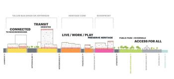
The east riverfront in Detroit has seen a number of new developments and revitalization efforts in recent years. The centerpiece of these efforts is the Detroit RiverFront Conservancy, which has worked since 2003 to incorporate walkways, parks, and other public space along the riverfront.
The new riverfront includes additional plazas, trails and boardwalks, public art, and green spaces, along with a number of parks, such as Stroh’s River Place and the Detroit RiverWalk, which includes the Dequindre Cut and Milliken State Park. There are also new residential projects, retail and dining establishments, and event spaces, along with pedestrian and bicycle pathways that provide access to GreenLink, the light rail system that connects downtown Detroit to Eastern Market and Belle Isle.
The project is a boon for not just Detroiters, but for visitors to the city as well, offering unique views of the water and downtown skyline, plus direct access to a variety of popular establishments such as Eastern Market, the Detroit Institute of Arts, and the Riverwalk Cafe.